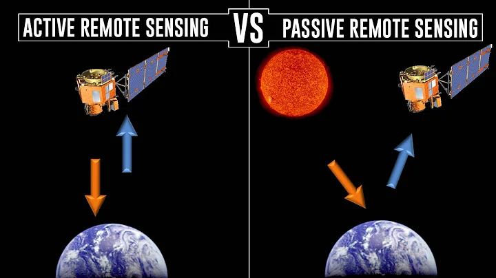
In today's world of modern technology, satellites have become an essential part of our day-to-day lives. These orbiting machines have revolutionized several sectors such as communication, navigation, weather forecasting, and Earth observation. Satellites are fitted with various types of sensors that enable them to collect and transmit data back to Earth. Satellite sensors have many different applications, including military, civilian, and scientific research. These sensors allow us to gather crucial information and imagery about our planet, helping us to monitor and understand our environment better. The various satellite sensors can be broadly classified into two categories: active and passive sensors. Active sensors emit energy that interacts with the Earth’s surface, while passive sensors measure radiation emitted by the Earth's surface. Each type of sensor has its own unique characteristics and applications, making them highly valuable in different fields. In this piece, we will explore the different types of satellite sensors and their applications, providing a better understanding of these technologies.
Chapter 1: What are Satellite Sensors and How Do They Work?
Satellite sensors are the eyes of a satellite, allowing it to capture images and data about the Earth from space. These sensors come in different types, each with its own unique characteristics and applications. In this chapter, we will explore the different types of satellite sensors and how they work.
Active Sensors vs Passive Sensors
There are two main categories of satellite sensors - active sensors and passive sensors. Active sensors emit their own energy source (such as radar) towards a target on Earth's surface while passive sensors detect natural radiation emitted from the Earth's surface (such as that emitted from sunlight).
Active sensing provides additional information about objects on or beneath Earth's surface that cannot be obtained by passive sensing alone. Radar is an example of an active sensor used for remote sensing applications such as mapping terrain or detecting oil spills in oceans.
Passive sensing is commonly used to capture imagery of land cover, vegetation health, ocean temperature variations among others.
Electro-optical Sensor
Electro-optical (EO) sensor technology uses visible light or near-infrared radiation to create high-resolution imagery that can be used for detailed analysis of land use patterns, vegetation health assessment among others.
EO imaging cameras have improved over time providing high resolution images at a low cost making them accessible to researchers across various fields including agriculture management among other application areas.
Thermal Infrared Sensor
The Thermal Infrared sensor detects radiation emitted by objects at thermal wavelengths not visible to human eyes. This type of imaging allows for studies in areas like weather forecasting where temperature is important; detecting heat loss/leakage within buildings; studying forest fires by detecting changes in temperature before smoke appears among other application areas.
Synthetic Aperture Radar Sensor
Synthetic aperture radar (SAR) is an active sensor system emitting microwaves which bounce back off targets on the ground creating complex images which provide additional information compared to passive sensors. SAR systems can create images in all weather conditions, day or night; penetrate clouds and vegetation cover, which makes them useful for applications such as disaster management, sea ice mapping among others.
Multispectral Imaging Sensor
Multispectral imaging sensor technology captures images by measuring the reflection of different wavelengths of light. These wavelengths correspond to specific features like land cover types and vegetation health. The multispectral approach allows researchers to study a wide range of features on Earth's surface without sacrificing image resolution or quality.
Hyperspectral Sensor
Hyperspectral imaging sensors capture data across many narrow spectral bands (more than 50) providing unique signatures for various objects including natural and man-made materials. This type of sensing is used in precision agriculture where information about soil moisture levels is critical for crop yield predictions.
Satellite sensors provide crucial data that can be used for various applications including monitoring global temperature changes, agricultural productivity assessment among others. Understanding the different types available helps researchers choose the best option(s) depending on their needs while taking into consideration factors like image resolution, cost among other factors influencing use cases.
Chapter 2: The Types of Satellite Sensors and Their Uses
Satellite sensors are used for a variety of purposes, from monitoring natural disasters to predicting crop yields. In this chapter, we will discuss the different types of satellite sensors and their uses.
EO Sensors and Their Uses
EO sensors work by detecting visible light or near-infrared radiation emitted from the Earth's surface. These types of sensors are widely used in environmental studies and agriculture management among other applications. They include:
Optical Imaging Sensor
Optical imaging sensors capture high-resolution images that enable researchers to monitor changes in land use patterns, vegetation health assessment among others.
Multispectral Imaging Sensor
Multispectral imaging technology captures data at various points across the electromagnetic spectrum, allowing researchers to study a wide range of features on Earth's surface without sacrificing image resolution or quality. Some applications include:
- Crop yield prediction
- Vegetation analysis
- Soil moisture measurement
SAR Sensors and Their Uses
SAR is an active sensor that emits microwaves towards the Earth's surface before analyzing the signals reflected back to create complex images with additional information compared to passive sensing alone. SAR technology has many useful applications including:
Disaster Management
SAR can penetrate through clouds making it ideal for disaster management where fast response time is needed during natural disasters such as earthquakes or volcanic eruptions.
Sea Ice Mapping
SAR can detect variations in sea ice thickness which helps scientists study climate change effects on polar regions.
Thermal Infrared Sensors and Their Uses
Thermal infrared (TIR) sensors detect radiation emitted by objects at thermal wavelengths not visible to human eyes. These types of sensing allow for studying temperature changes within buildings; forest fires detection by detecting changes in temperature before smoke appears among other application areas like:
Weather Forecasting
Hyperspectral Sensors and Their Uses
Hyperspectral imaging sensors capture data across many narrow spectral bands providing unique signatures for various objects. This type of sensing is used in many applications, including:
Precision Agriculture
Hyperspectral imaging can map soil moisture levels which help predict crop yields and optimize irrigation schedules.
Gravity Sensors and Their Uses
Gravity sensors measure the Earth's gravitational field, allowing researchers to study changes in mass distribution over time. Some applications include:
Oceanography
Gravity sensors can detect variations in the sea level caused by ocean currents or tides.
Magnetometer Sensors and Their Uses
Magnetometer sensors measure changes in the Earth's magnetic field, making them useful for a variety of applications including:
Geological Survey
Magnetometers are used to survey land formations like mineral deposits or oil fields.
Chapter 3: Advancements in Satellite Sensing Technology
Satellite sensing technology has come a long way since the first satellite was launched in 1957. With advancements in technology, satellites are now capable of capturing images and data with greater accuracy and detail than ever before. In this chapter, we will explore some of the recent advancements in satellite sensing technology.
Improved Image Resolution
One significant advancement in satellite sensing technology is improved image resolution capabilities. Satellites can now capture images with resolutions as high as 30 cm from space. This level of detail enables researchers to study objects on Earth's surface at a much finer scale than previously possible.
Enhanced Spectral Bands
Another significant advancement is the ability to capture data across more spectral bands than before. These additional bands provide more information about objects on Earth's surface, such as their composition and temperature.
High-Speed Data Transmission
Advancements have been made to increase satellite transmission speeds through high-speed internet connections between ground stations and orbiting satellites which allows researchers access to real-time data that can improve response time during emergencies such as natural disasters or forest fires among other applications.
Improved Sensor Calibration
Calibration is crucial for ensuring that sensor measurements are accurate over time, regardless of environmental changes like temperature or humidity fluctuation among others affecting sensor performance. Modern-day sensors have calibration routines that mitigate these issues by maintaining consistent measurements over time providing reliable results used for scientific studies among other applications.
Artificial Intelligence Integration
Artificial intelligence (AI) has been integrated into remote sensing systems allowing for automated image analysis including object detection, classification and recognition which saves time while improving efficiency levels compared to manual image interpretation methods.
Chapter 4: The Future of Satellite Sensors and Their Impact on Society
The future of satellite sensors is bright, and it is expected that advancements in technology will continue to revolutionize the way we monitor and study our planet. In this chapter, we will discuss some of the potential applications for satellite sensing technology in the future and how it may impact society.
Climate Change Monitoring
Disaster Management
Satellite sensors can be used to predict natural disasters such as hurricanes or tsunamis among others before they occur allowing affected areas enough time to evacuate or prepare accordingly which saves lives while minimizing property damage.
Precision Agriculture
Satellite sensing technology can play a significant role in agriculture management through precision farming. By using high-resolution imaging techniques like hyperspectral imaging; multispectral imaging farmers can optimize their crop production processes by analyzing soil moisture levels; detecting crop diseases early on among other factors influencing crop yield.
Telecommunications Support
Satellite sensors provide reliable communication links with remote areas that lack access to traditional terrestrial-based communication methods which makes them ideal for use in emergency situations where quick response times are critical.
Improved Navigation Systems
Advancements in satellite sensing technology have improved navigation systems accuracy levels including GPS navigation making them increasingly useful for scientific research expeditions among other applications requiring accurate location data.
FAQs
What are the different types of satellite sensors that a person may have?
There are several types of satellite sensors that different organizations frequently use. The most common ones include optical sensors, thermal sensors, microwave sensors, and radar sensors. Optical sensors capture images of the Earth's surface using visible or near-infrared light, while thermal sensors record radiation emitted by the planet and produce temperature data. Microwave sensors depend on microwave radiation to identify objects on the ground and have excellent penetration capability, making them ideal for identifying subsurface features. Finally, radar systems use radio waves to precisely track movement on the Earth's surface and are useful for measuring ocean currents, monitoring ice sheets, and identifying infrastructure damage during natural disasters.
What are the applications of optical sensors?
Optical sensors are one of the most widely used satellite sensors for a variety of applications. They provide high-resolution imagery that can be used for mapping, monitoring the environment, studying wildlife, identifying land-use patterns, and detecting changes in coastal zones. They also have significant scientific applications like studying the effects of climate change on the earth, vegetation distribution and dynamics, and detecting wildfires.
What is the main advantage of using thermal sensors?
Thermal sensors have an enormous advantage when it comes to acquiring data that is crucial in weather forecasting. They can measure the Earth's temperature precisely, even in thick clouds or at night, providing complete thermal maps of the Earth's climate zones. Additionally, these sensors have several applications in monitoring the output and thermal energy of power plants and detecting urban heat islands.
What are the key features of radar satellite sensors?
Radar sensors are best known for their ability to capture imagery through clouds and darkness. Moreover, they frequently have high resolution and monitoring capability, allowing the detection of changes in the Earth's surface over time. One benefit of radar satellite sensors is their capability to penetrate the soil layer and produce information about the subsurface features. They are widely used for maritime monitoring, ice sheet and glacier motion monitoring, military intelligence, and environmental hazard detection.


